


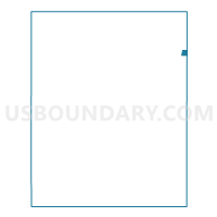
Sabetha Ward 4, Nemaha County, Kansas
About
Outline

Summary
| Unique Area Identifier | 586070 |
| Name | Sabetha Ward 4 |
| County | Nemaha County |
| State | Kansas |
| Area (square miles) | 0.50 |
| Land Area (square miles) | 0.50 |
| Water Area (square miles) | 0.00 |
| % of Land Area | 100.00 |
| % of Water Area | 0.00 |
| Latitude of the Internal Point | 39.90866330 |
| Longtitude of the Internal Point | -95.79528480 |
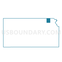
Maps

Graphs
Select a template below for downloading or customizing gragh for Sabetha Ward 4, Nemaha County, Kansas


Neighbors
Neighoring Voting District (by Name) Neighboring Voting District on the Map
- Berwick Township Voting District, Nemaha County, KS
- Morrill Township Voting District, Brown County, KS
- Rock Creek Township Enclave A Voting District, Nemaha County, KS
- Rock Creek Township Enclave B Voting District, Nemaha County, KS
- Sabetha Ward, Nemaha County, KS
- Sabetha Ward 1, Nemaha County, KS
- Sabetha Ward 1 Part A, Brown County, KS
- Sabetha Ward 2, Nemaha County, KS
Top 10 Neighboring County Subdivision (by Population) Neighboring County Subdivision on the Map
- Sabetha city, Nemaha County, KS (2,564)
- Morrill township, Brown County, KS (479)
- Rock Creek township, Nemaha County, KS (416)
- Berwick township, Nemaha County, KS (408)
- Sabetha city, Brown County, KS (7)